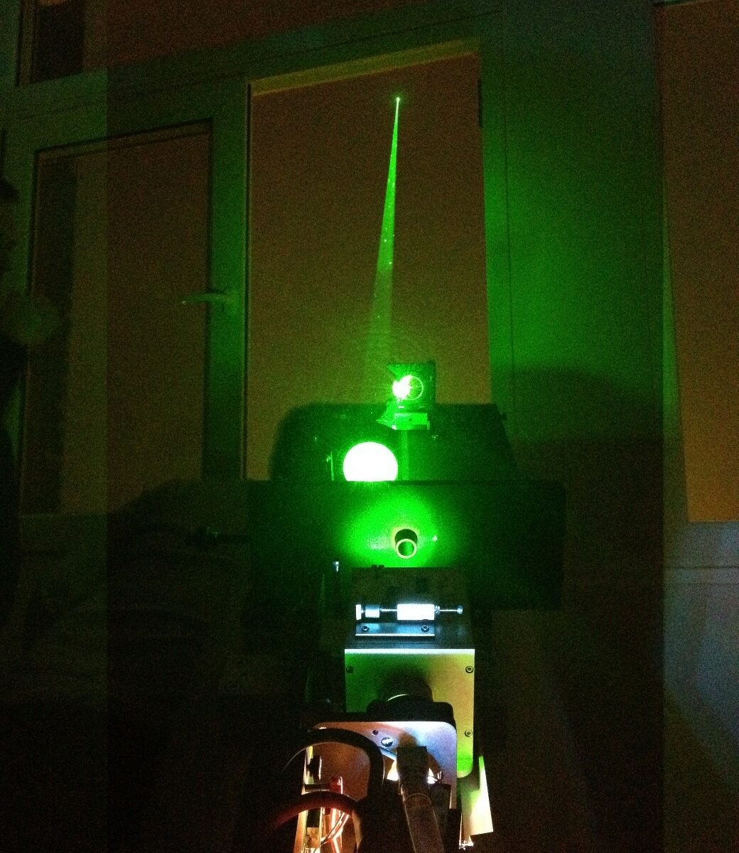
Multi-wavelength LILAS LiDAR Raman at the Laboratory of Atmospheric Optic (LOA).
Keywords : Aerosols, LiDARs, MicroLiDARs, monitoring, Earth observation, remote sensing, Raman, wavelengths, ash, dust, sand.
July 29th 2022
The Laboratoire d’optique atmosphérique (LOA) is a joint research unit of the National Center for Scientific Research (CNRS) of France and the University of Lille – Sciences and Technologies. The LOA studies the different components of the atmosphere, mainly clouds, aerosols and gas. In collaboration with the LOA, CIMEL created a joint research laboratory : AGORA-LAB.
Since 2005, the LOA has started the systematic observation of aerosols by LiDAR and has developed a database and an automated real-time data processing system. Its collaboration with CIMEL allowed the creation of the multi-wavelength LILAS LiDAR which was integrated into the European network EARLINET/ACTRIS in 2015.
The LILAS LiDAR was specifically designed and adjusted by CIMEL to meet a specific need of the LOA. The transportable multi-wavelength Raman research LiDAR LILAS offers a significant qualitative and quantitative value on aerosol parameters measured at night and during the day, in particular through its combination with CIMEL sun/sky/lunar photometers.
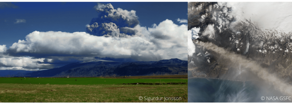
LILAS also allows the observation of clouds and the obtention water vapor and methane profiles. It also gives access to essential climate variables such as the absorption profile of atmospheric aerosols. Its maximum range can reach 20 km and allows it to study the lower stratosphere which can be useful in case of major volcanic eruption for example.
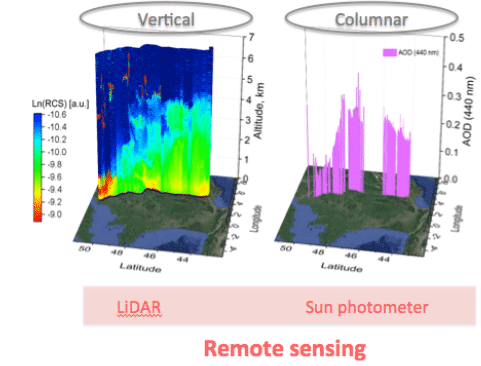
For the Data treatment, the AUSTRAL (AUtomated Server for the TReatment of Atmospheric Lidars) web server data is the processing tool, which provides real-time quicklooks of the LiDAR Range Corrected Signals (RCS) and Volume Depolarization Ratio (VDR) as well as Klett inversion results (extinction and backscatter coefficient profiles).
To answer the need of various stakeholders, the CE710 LiDAR is a fully customizable high power multi-channel aerosols LiDAR resulting from the collaboration between the LOA, CIMEL and Dr. Igor Veselovskii institute. Depending on the requirements and budgets of each, it exists multiple options to customize the LiDAR. For exemple, the choice of the laser type and the wavelengths, the depolarization options or the Raman options (and many more).
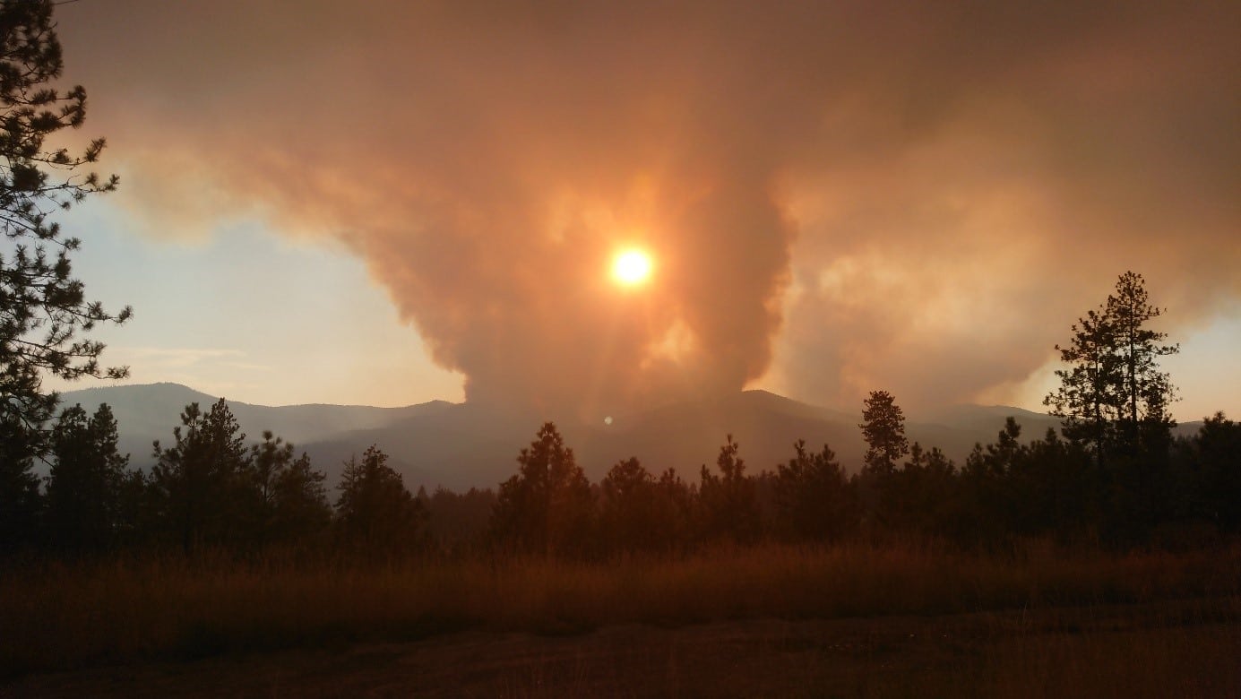
Thanks to its precision in the detection of aerosols, the LILAS CE710 LiDAR has highlighted many atmospheric natural events such as volcanic eruptions (ash) or dust and sand events for example but also biomass burning particles coming from fires. LILAS data and all the LiDAR’s activities between the LOA and CIMEL bring a precious monitoring tool to understand atmospheric phenomenas over France, Europe and worldwide.
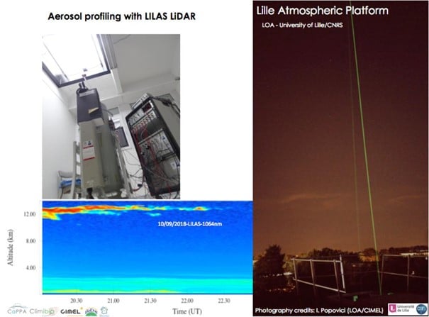
Figure 1 : View of LILAS (telescope, laser, and acquisition bay) in vertical view, open roof hatch and example of observed aerosol profiles. LILAS is a transportable multi-wavelength Elastic & Raman LiDAR. It has 3 elastic channels (355, 532 and 1064 nm), 3 Raman channels (387, 407 and 530 nm) and 3 depolarized channels (355, 532 and 1064 nm).
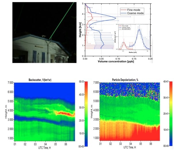
Figure 2: Night time LILAS operation during SHADOW-2 campaign in Senegal (Credits: Q. Hu, LOA)
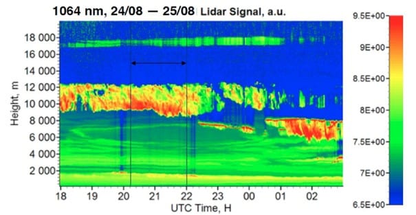
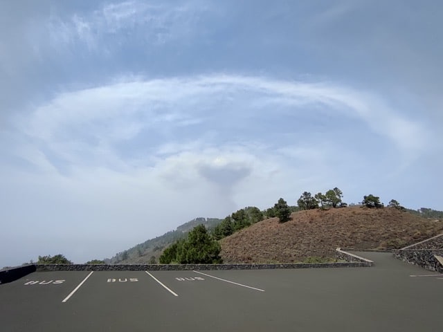
Figure 3 : Detection of smoke particles injected up to 17 km into the stratosphere by intense pyro-convection generated by the Canadian wildfires of summer 2017 (Hu et al., 2018).
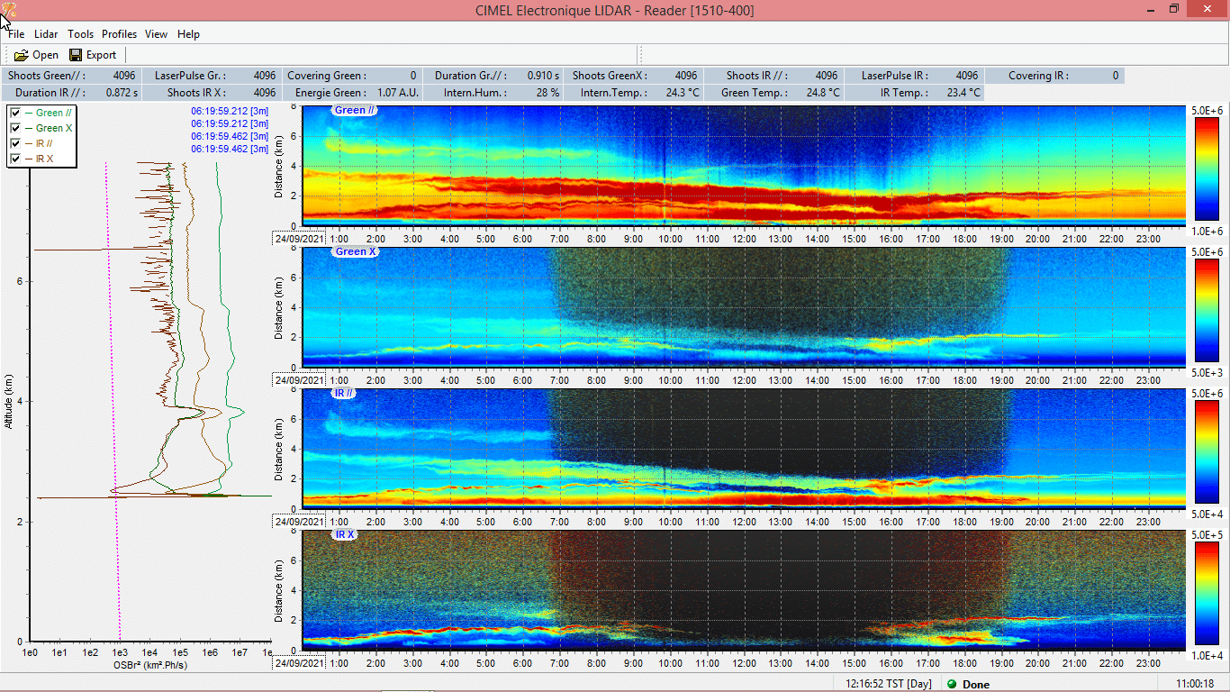
Figure 4: Illustration of the extreme event in October 2017. LiDAR LILAS time series from 16/10/17-16:00 to 17/10/17-06:00 UTC at the Lille site (LOA). (a) The reddest regions indicate a high concentration of particles while the blue regions indicate a very low concentration of particles. (b) Aerosol depolarization which informs us about the shape of the particles and thus their nature, desert or fire particles.
Graphic credits Q. Hu, LOA
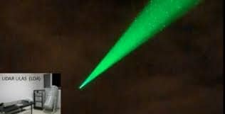
Figure 5: LiDAR LILAS LOA
Communications and posters
- Podvin T., P. Goloub, D. Tanré, I. Veselovskii, V. Bovchaliuk, M. Korensky, A. Mortier, S. Victori, .LILAS, un LIDAR multispectral et Raman pour l’étude des aérosols, de la vapeur d’eau et des nuages, Atelier Experimentation et Instrumentation 2014 (oral presentation)
- Podvin T, Q. Hu, P. Goloub, O. Dubovik, I. Veselovskii, V. Bovchaliuk, A. Lopatin, B. Torres, D. Tanré, C. Deroo, T. Lapyonok, F. Ducos, A. Diallo. , LILAS, le Lidar multi spectral Raman polarisé et quelques résultats d’inversions, Atelier Experimentation et Instrumentation 2017 (poster presentation).
- Hu et al., Aerosol absorption measurements and retrievals in SHADOW2 campaign, ICAC 2017, International Conference on Aerosol Cycle, 21 – 23 Mar, Lille
- Hu et al., A test of new approaches to retrieve aerosol properties from Photometer-LiDAR joint measurements, ESA/IDEAS Workshop 2017, Lille, 06-07 Apr 2017
- Hu et al., Retrieval of aerosol properties with Sun/Sky-photometer and LiDAR measurements, ACTRIS-FR, Workshop, Autrans Méaudre en Vercors, 3-5 mai 2017
- Hu et al., Retrieval of aerosol properties with Sun/Sky-photometer and LiDAR measurements, 28th ILRC, international LiDAR and Radar conference, Bucharest, 25 – 30 June
- Hu et al., Lidar measurements with 3-depolarization in Lille, 3rd ACTRIS-2 WP2 Workshop, Delft, 13-17 Nov 2017.
- Podvin. T, Q. Hu, P. Goloub, I. Veselovskii, C. Deroo, G. Dubois, T. Trivellato, I. Popovici, B. Torres. Aerosol Remote Sensing at Lille observation platform: upgrade of profiling capabilities. ACTRIS-2 / WP2 Aerosol Profiling – Hatfield – 19-23 November 2018, United Kingdom (présentation poster) http://www-loa.univ-lille1.fr/documents/LOA/posters/20181115_poster_LILAS_WP2_2018.pdf
- Qiaoyun Hu, Juan-Antonio Bravo Aranda, Ioana Popovici, Philippe Goloub, Thierry Podvin, Igor Veselovskii, Martial Haeffelin, Christophe Pietras, Transported smoke layers detected over northern France, EGU, 2018 (présentation poster) http://www-loa.univ-lille1.fr/documents/LOA/posters/2018_EGU_Hu.pdf