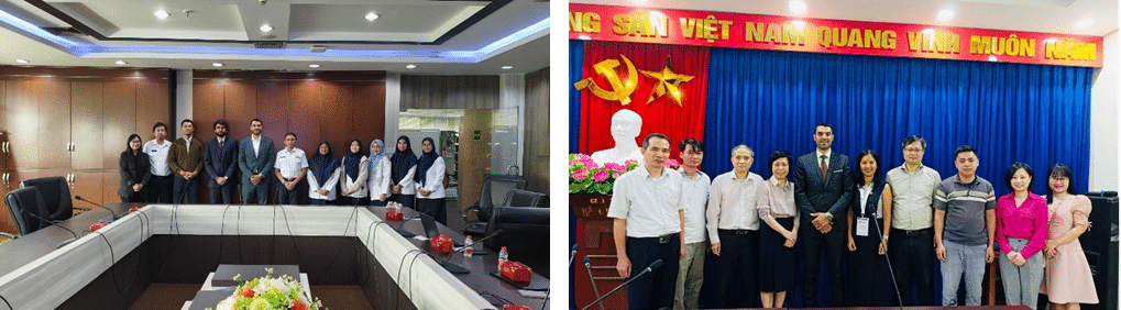
As part of the official visit of French President Emmanuel Macron to Southeast Asia in May 2025, a delegation of French companies and institutions took part in a strategic mission in Vietnam and Indonesia under the “France-Vietnam: A Shared Future” initiative.
CIMEL, represented by Idris SANHAJ, our Sales and Marketing Director, was honored to be part of the French delegation, reaffirming our commitment to international scientific and environmental cooperation.
During this mission, CIMEL had the opportunity to engage with several national authorities and scientific institutions:
In Indonesia, Idris visited the BMKG (Badan Meteorologi, Klimatologi, dan Geofisika), the national agency for meteorology, climatology, and geophysics, to explore avenues for collaboration on atmospheric observation and extreme weather monitoring (picture on the left).
In Vietnam, he met with the Vietnam Academy of Science and Technology (VAST) and several research teams to discuss cooperation in aerosol monitoring, dust events, and solar radiation measurements (picture on the right).
This mission, supported by Team France Export and the French Embassy, highlighted CIMEL’s role as a key player in atmospheric observation technologies in the Asia-Pacific region — particularly in the context of the Just Energy Transition Partnership (JETP) and climate change adaptation strategies.
We are deeply grateful to all our partners for their warm welcome and shared ambition to tackle pressing environmental challenges through science and innovation.
CIMEL is proud to contribute to global initiatives for a cleaner, more resilient, and sustainable future.
French President Emmanuel Macron Leads CIMEL and Various French Companies in Brazil for Economic Diplomacy and Green Transition Innovation
Keywords: Aerosols, monitoring, remote sensing, green transition, innovation.
March 25-28th 2024
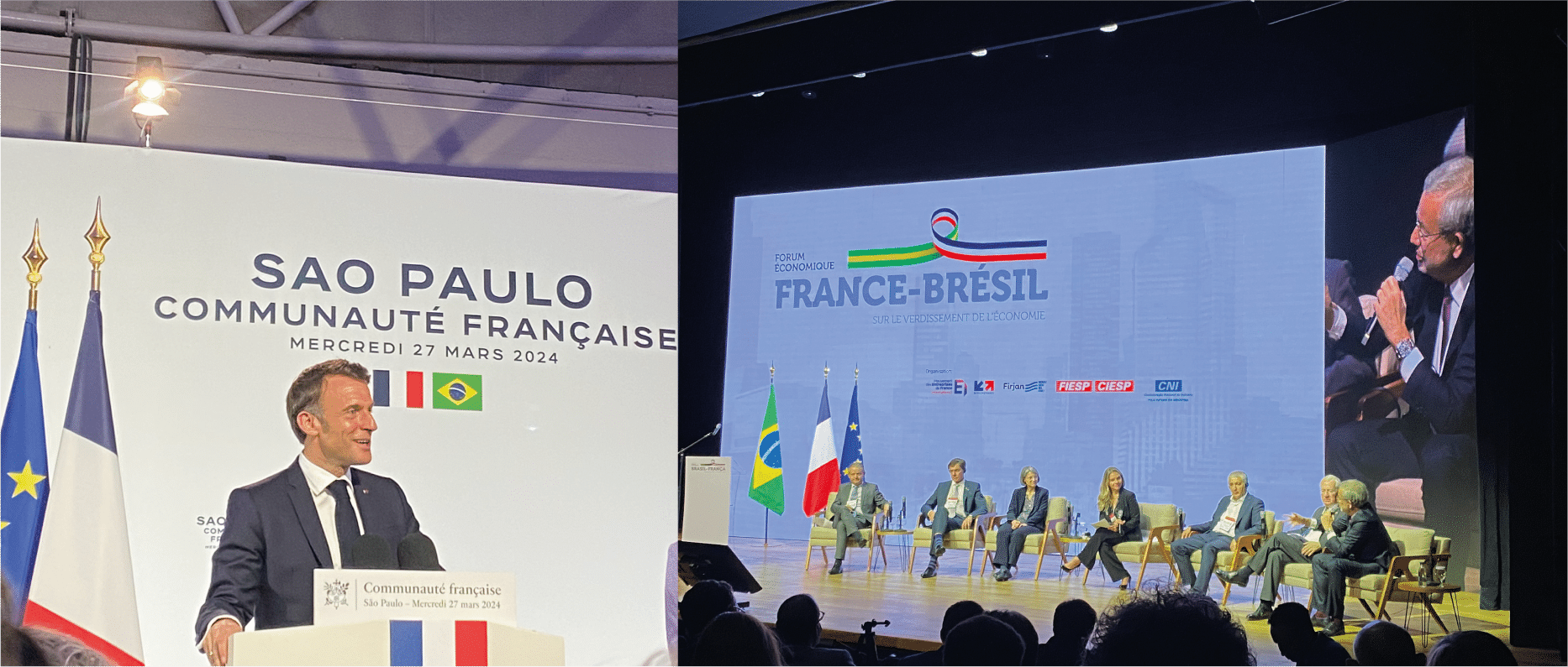
Once again CIMEL had the honor to be part of the French delegation accompanying the French president Emmanuel MACRON this time in Brazil in São Paulo from 25th to 28th March 2024.
Organized by MEDEF International and Business France, this delegation of over 80 French companies was embarking on a journey to Brazil, aimed at fostering stronger economic ties between the two countries.
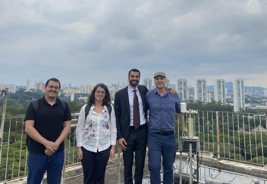
Through a comprehensive agenda created around multiple business possibilities, heavy discussions have been conducted between French companies and other stakeholders. CIMEL, in particular, has actively participated in meetings with significant entities such as the Brazilian Space Agency (INPE), the University of São Paulo, the Institute of Advanced Studies (IPEN), as well as ministers and responsible for finance, cities, energy, and environment.
Encounter with the Remote Sensing experts from the University of São Paulo.
It was particularly interesting for CIMEL to meet these scientific entities in sectors such as space research, advanced technology, and energy, as these areas align closely with CIMEL’s expertise and potential for collaboration and innovation.
CE318 site – University of São PauloCIMEL visiting the University of São Paulo
The most popular event of the visit is the Franco-Brazil Business Forum addressing energy transition, which involves President Macron and Geraldo Alckmin – the Vice-President of Brazil. The Forum discussed the initiatives of how the investments will change color into “green” for both governments and revealed plans for sustainable development.
CIMEL meeting the French President during the Business Forum.
The presence of Laurent Saint-Martin, Director General of Business France, brought a decisive vision of the strengths of France with its delegation.
As CIMEL continues to forge ahead in its quest for international expansion, this business trip served as a demonstration of its commitment to innovation, collaboration, and global leadership in the sector of atmospheric and environmental monitoring.
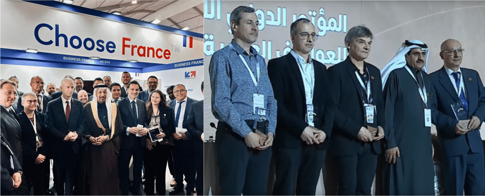
🇫🇷 🇸🇦 | Exciting times for 120 French companies as Business France, led by Franck Riester and in collaboration with the Secretariat General for Investment and the Movement of French International Enterprises, ventures into Saudi Arabia.
Saudi Arabia is undergoing a significant metamorphosis, offering unparalleled opportunities for French companies of all sizes across various sectors. CIMEL is actively contributing to this innovative transformation.
NEOM City, a groundbreaking project, stands as a symbol of Saudi Arabia’s ambition for the future. This futuristic city, focusing on innovation and sustainability, presents immense possibilities for collaboration and investment. CIMEL, recognizing its potential, is actively engaged in discussions and presentations to showcase its expertise in contributing to NEOM’s environmental purposes.
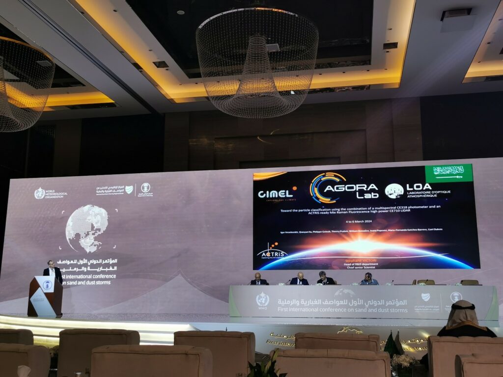
Furthermore, last week marked the beginning of the 1st International Conference on Sand and Dust Storms, hosted by the National Center for Meteorology in #KSA, with CIMEL’s involvement. Follow the three days of lectures at https://youtu.be/rVHzYSVog_U, where CIMEL played a key role in sharing insights and ongoing activities related to #SDS within WMO and the United Nations.
An inspiring week, where CIMEL’s dual commitment to economic transformation and environmental responsibility takes center stage.
Dr. Stéphane VICTORI speech during the First International Conference on Sand and Dust Storms
CIMEL was able to explain how our cutting-edge technology enhances aerosols remote sensing capabilities. The synergy between our aerosol photometers and LiDARs, integrated into the iAAMS software, allows for comprehensive data analysis and visualization of aerosols (characterization, location, concentration…). The incorporation of the GRASP algorithm refines aerosol characterization and better concentration profiles, proving invaluable in monitoring sand and dust storms. This technological advancement highlights a collective commitment to economic transformation and environmental responsibility, positioning CIMEL as a key player in a sustainable future.
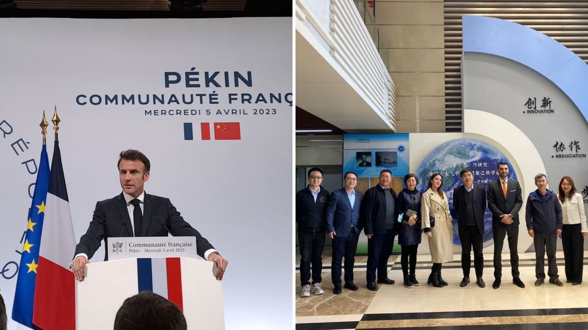
CIMELin the French delegation of the French President on his mission in China.
CIMEL is proud to have accompanied the French President Emmanuel Macron on his mission in China, organized in collaboration with Business France and the French Embassy from April 3rd to 7th 2023.
This was an important geopolitical event, as we were part of the first French delegation to come back in China after the reopening of the borders and the lifting of sanitary restrictions linked to COVID-19.
It was also an opportunity for companies such as ours (with special regards to Chromatotec, ENVEA Group, Greentech Innovation) to shine through lobbying and gathering decision makers on climate change and environmental issues.
Our Sales and Marketing Director, Idris SANHAJ and our International Business Developer Laura MARIT have represented CIMEL through business meetings with our Chinese partners (CMA Chinese Meteorological Agency, CAS Chinese Academy of Sciences, Environmental Monitoring Centers of Shanghai Municipality and Jiangsu Province, Guangzhou University…) and to exchange ideas with various members of the French delegation organized by Business France.
They had the opportunity to encounter the French President Emmanuel Macron and had a brief meeting with the Minister of Economy and Finance Bruno Lemaire to discuss the future of air quality application with our innovative solutions, in particular for the JO2024 Olympic Games in Paris.
During this mission, CIMEL has presented its remote sensing solutions for aerosols monitoring, used to increase the understanding of atmospheric phenomenas, improve and validate air quality models.
This combination of climate modeling, through in-situ sensors, satellite data, and ground remote sensing, allows for more accurate air quality forecasting and decision-making for public health and environmental management.
We look forward to continuing to serve our customers in China and across the globe with the same level of excellence and dedication that has become synonymous with our brand Made in France.
🙏 We extend our gratitude to Business France (Laurent Saint-Martin, Xavier CHATTE-RUOLS, Baptiste DELBENDE, Nicolas SESTIER), teamfranceexport (Valérie Alvarado-Zongo, Yang Yang, Michelle Portugal, Lian Qu), and CCI FRANCE CHINE (Caroline Penard, Christophe Lauras) for coordinating this successful business trip.
The Cyprus Institute is non-profit research and educational institution with a strong scientific and technological orientation.
The Institute is divided into four research centers:
Energy, Environment and Water Research Center (EEWRC)
Science and Technology in Archeology and Culture Research Center (STARC)
Computation-based Science and Technology Research Center (caSToRC)
Climate & Atmosphere Research Center (CARE-C)
The Climate and Atmosphere Research Center (CARE-C) was founded at the Cyprus Institute in January 2020. It is a regional European Center of Excellence for Climate and Atmosphere Research, based in Cyprus, for the Eastern Mediterranean and Middle East (EMME) region. The aim of the center is to lead some researches about urgent climate change and air pollution challenges such as greenhouse gases, the water cycle, extreme weather, atmospheric dust and their impacts.
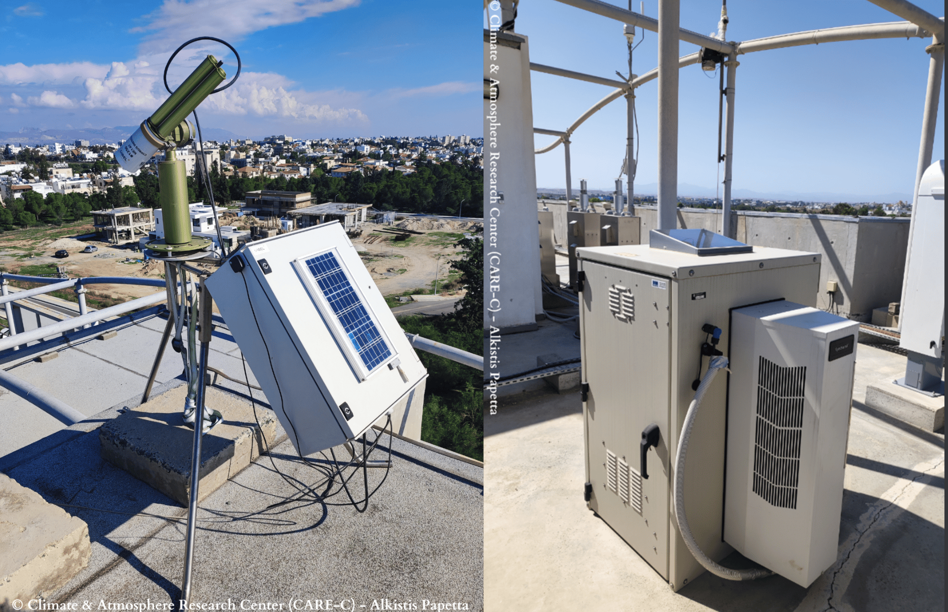
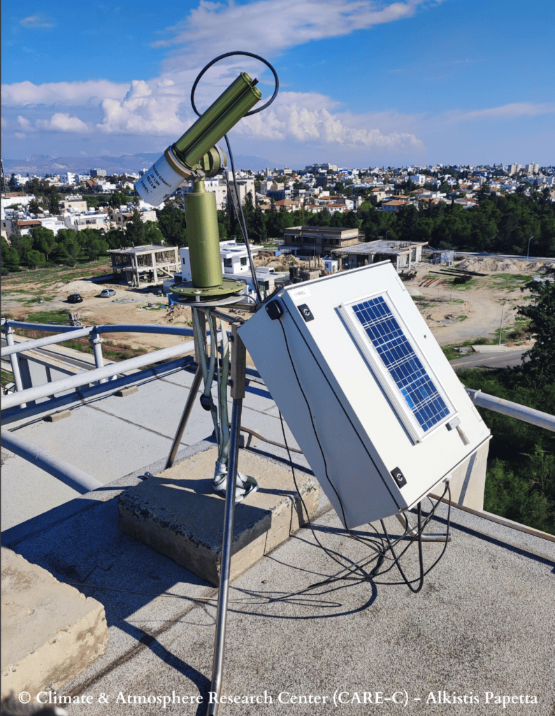
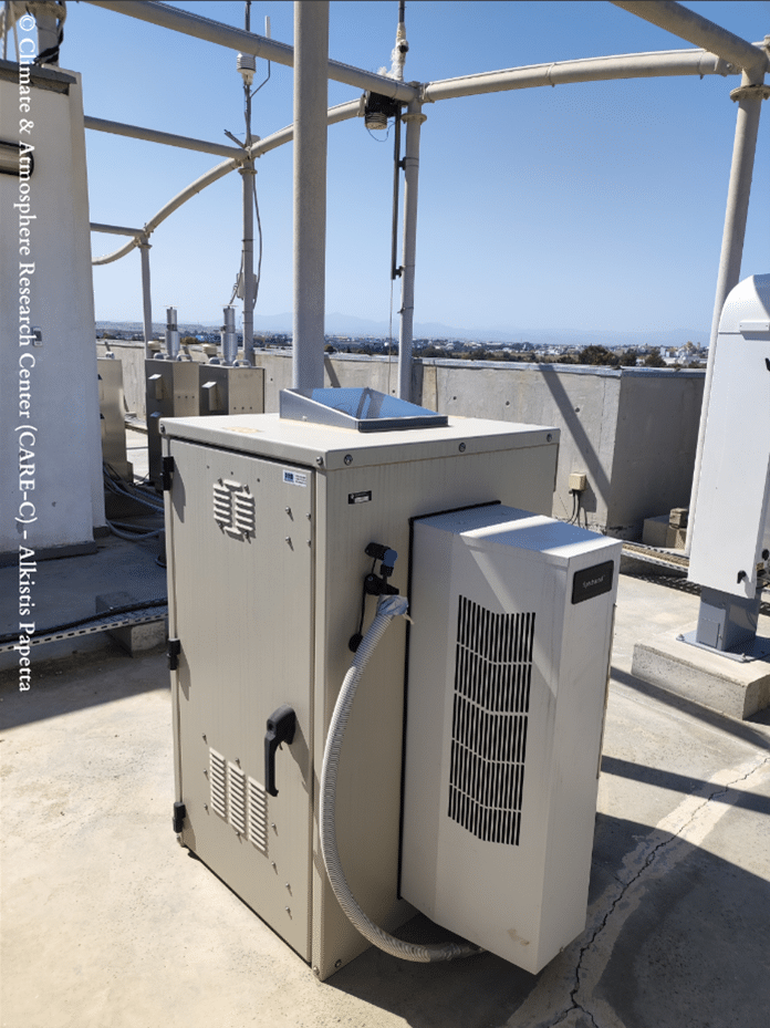
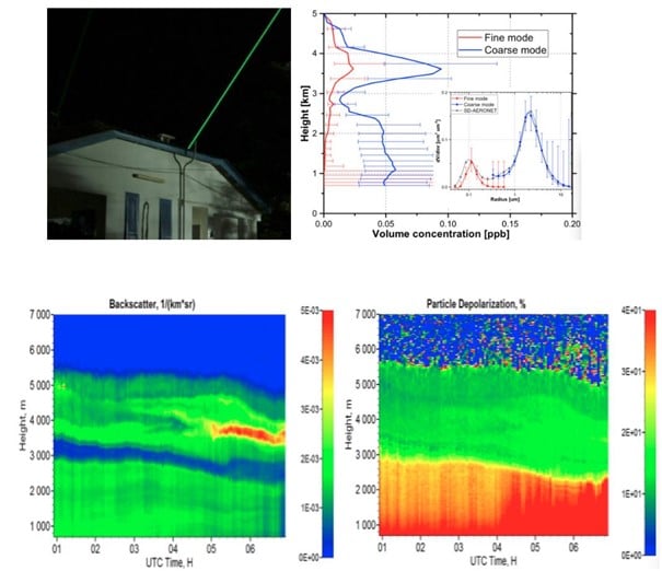
Therefore, the center owns a remote sensing group composed by a network of ground-based instruments located at three Cyprus Atmosphere Observatory (CAO) stations: Nicosia, Agia Marina Xyliatou and Troodos. Among these instruments, three CE318-T – Sun Sky Lunar Multispectral Photometersand a CE376 – Compact LiDAR.
CIMEL AAMS – Automatic Aerosol Monitoring Solutionallows the study of the transportation of pollution, dust, smoke and all the aerosols related to atmospheric composition. For instance, optical characterization of dust and smoke particles are made thanks to the 2 wavelengths CE376 – Compact LiDAR. In addition,the instrument has depolarization capability, which is a relevant information for aerosols typing.
By using state-of-the-art solutions and collaborating with the Laboratoire d’Optique Atmosphérique (LOA – University of Lille/CNRS), the CAO provides high quality, long-term observations of key atmospheric pollutants relevant to air quality and climate change, and thus, brings value to the Cyprus Institute in different sectors such as Research, Innovation and Education. This collaboration is developing for many years in the frame of aerosol monitoring (AERONET), radiative flux monitoring and more recently with automatic Lidar/photometer synergy, in the frame of ACTRIS. Moreover, the cooperation between LOA and CAO, in the frame of AQABA campaign, allowed the first operation of the prototype shipborne version of CE318T.
Figure 1 : CE318-T – Sun Sky Lunar Multispectral photometer at Nicosia station.
Figure 2 : CE376 – Micro LiDAR at Nicosia station.
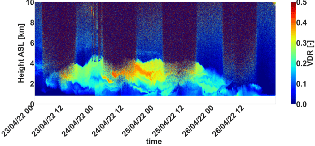
Figure 3 : Quicklook of the volume depolarization ratio during a dust event in Cyprus.
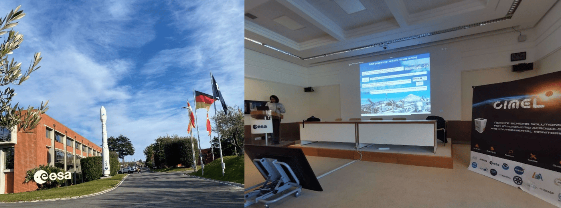
SOlar Radiation Based Established Techniques for aTmospheric Observations (SORBETTO) Winter school took place from February 6th to 10th atESA-ESRIN(European Space Research Institute), in Frascati, Italy and was organized in collaboration with Sapienza University(Roma) and CNR-ISAC (National Research Council – Institute of Atmospheric Sciences and Climate).
SORBETTO is an important training event for young researchers collaborating within the international aerosol’s scientific community (gas and aerosol observations for climatological, meteorological, local and global air pollution studies, remote sensing and in-situ measurements, calibration of satellite measurements…).
Ground-based instruments deployed in Networks such as AERONET are key players to perform high quality observations that contribute to the Validation and Calibration (CAL/VAL) of satellite missions. Instruments such as Sun Sky Lunar Photometers or LiDARs allow to check that information derived from satellite sensors is comparable to ground measurements and thus, to validate their accuracy.
CIMEL Team operating an instrumental demonstration of CE318-T Sun Sky Lunar Photometer at University of Sapienza, 9th 2023.
The instrument show held on Thursday 9th at Sapienza University was the opportunity for students to attend a presentation of various solutions such as CIMEL CE318-T Sun Sky Lunar Photometer, exclusive instrument of NASA Aerosol Network AERONET.
It was a pleasure for CIMEL to attend the event with our great and exclusive Italian Business Partner XEarPro Srl. With 20 years of experience in the field of environmental monitoring, XEarpro Srl contributes in the development of applications and solutions to safeguard the environment around us. We collaborate closely to meet the needs of the Italian scientific community in term of aerosols remote sensing instruments.
The Laboratoire d’optique atmosphérique (LOA) is a joint research unit of the National Center for Scientific Research (CNRS) of France and the University of Lille – Sciences and Technologies. The LOA studies the different components of the atmosphere, mainly clouds, aerosols and gas. In collaboration with the LOA, CIMEL created a joint research laboratory : AGORA-LAB.
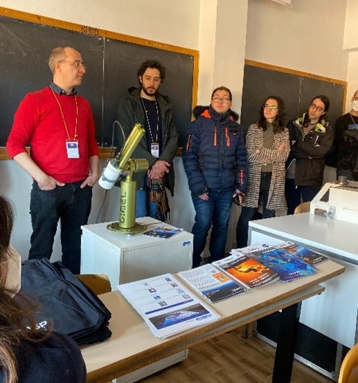
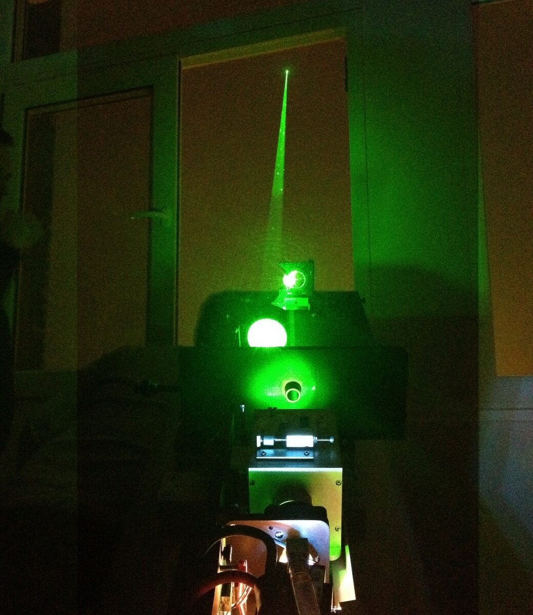
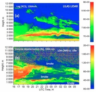
Since 2005, the LOA has started the systematic observation of aerosols by LiDAR and has developed a database and an automated real-time data processing system. Its collaboration with CIMEL allowed the creation of the multi-wavelength LILAS LiDAR which was integrated into the European network EARLINET/ACTRIS in 2015.
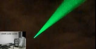
The LILAS LiDAR was specifically designed and adjusted by CIMEL to meet a specific need of the LOA. The transportable multi-wavelength Raman research LiDAR LILAS offers a significant qualitative and quantitative value on aerosol parameters measured at night and during the day, in particular through its combination with CIMEL sun/sky/lunar photometers.
LILAS also allows the observation of clouds and the obtention water vapor and methane profiles. It also gives access to essential climate variables such as the absorption profile of atmospheric aerosols. Its maximum range can reach 20 km and allows it to study the lower stratosphere which can be useful in case of major volcanic eruption for example.
For the Data treatment, the AUSTRAL (AUtomated Server for the TReatment of Atmospheric Lidars) web server data is the processing tool, which provides real-time quicklooks of the LiDAR Range Corrected Signals (RCS) and Volume Depolarization Ratio (VDR) as well as Klett inversion results (extinction and backscatter coefficient profiles).
To answer the need of various stakeholders, the CE710 LiDAR is a fully customizable high power multi-channel aerosols LiDAR resulting from the collaboration between the LOA, CIMEL and Dr. Igor Veselovskii institute. Depending on the requirements and budgets of each, it exists multiple options to customize the LiDAR. For exemple, the choice of the laser type and the wavelengths, the depolarization options or the Raman options (and many more).
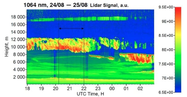
Thanks to its precision in the detection of aerosols, the LILAS CE710 LiDAR has highlighted many atmospheric natural events such as volcanic eruptions (ash) or dust and sand events for example but also biomass burning particles coming from fires. LILAS data and all the LiDAR’s activities between the LOA and CIMEL bring a precious monitoring tool to understand atmospheric phenomenas over France, Europe and worldwide.
Figure 1 : View of LILAS (telescope, laser, and acquisition bay) in vertical view, open roof hatch and example of observed aerosol profiles. LILAS is a transportable multi-wavelength Elastic & Raman LiDAR. It has 3 elastic channels (355, 532 and 1064 nm), 3 Raman channels (387, 407 and 530 nm) and 3 depolarized channels (355, 532 and 1064 nm).
Figure 2: Night time LILAS operation during SHADOW-2 campaign in Senegal (Credits: Q. Hu, LOA)
Figure 3 : Detection of smoke particles injected up to 17 km into the stratosphere by intense pyro-convection generated by the Canadian wildfires of summer 2017 (Hu et al., 2018).
Figure 4: Illustration of the extreme event in October 2017. LiDAR LILAS time series from 16/10/17-16:00 to 17/10/17-06:00 UTC at the Lille site (LOA). (a) The reddest regions indicate a high concentration of particles while the blue regions indicate a very low concentration of particles. (b) Aerosol depolarization which informs us about the shape of the particles and thus their nature, desert or fire particles. Graphic credits Q. Hu, LOA
Figure 5: LiDAR LILAS LOA
Communications and posters
Podvin T., P. Goloub, D. Tanré, I. Veselovskii, V. Bovchaliuk, M. Korensky, A. Mortier, S. Victori, .LILAS, un LIDAR multispectral et Raman pour l’étude des aérosols, de la vapeur d’eau et des nuages, Atelier Experimentation et Instrumentation 2014 (oral presentation)
Podvin T, Q. Hu, P. Goloub, O. Dubovik, I. Veselovskii, V. Bovchaliuk, A. Lopatin, B. Torres, D. Tanré, C. Deroo, T. Lapyonok, F. Ducos, A. Diallo. , LILAS, le Lidar multi spectral Raman polarisé et quelques résultats d’inversions, Atelier Experimentation et Instrumentation 2017 (poster presentation).
Hu et al., Aerosol absorption measurements and retrievals in SHADOW2 campaign, ICAC 2017, International Conference on Aerosol Cycle, 21 – 23 Mar, Lille
Hu et al., A test of new approaches to retrieve aerosol properties from Photometer-LiDAR joint measurements, ESA/IDEAS Workshop 2017, Lille, 06-07 Apr 2017
Hu et al., Retrieval of aerosol properties with Sun/Sky-photometer and LiDAR measurements, ACTRIS-FR, Workshop, Autrans Méaudre en Vercors, 3-5 mai 2017
Hu et al., Retrieval of aerosol properties with Sun/Sky-photometer and LiDAR measurements, 28th ILRC, international LiDAR and Radar conference, Bucharest, 25 – 30 June
Hu et al., Lidar measurements with 3-depolarization in Lille, 3rd ACTRIS-2 WP2 Workshop, Delft, 13-17 Nov 2017.
Podvin. T, Q. Hu, P. Goloub, I. Veselovskii, C. Deroo, G. Dubois, T. Trivellato, I. Popovici, B. Torres. Aerosol Remote Sensing at Lille observation platform: upgrade of profiling capabilities. ACTRIS-2 / WP2 Aerosol Profiling – Hatfield – 19-23 November 2018, United Kingdom (présentation poster) http://www-loa.univ-lille1.fr/documents/LOA/posters/20181115_poster_LILAS_WP2_2018.pdf
Qiaoyun Hu, Juan-Antonio Bravo Aranda, Ioana Popovici, Philippe Goloub, Thierry Podvin, Igor Veselovskii, Martial Haeffelin, Christophe Pietras, Transported smoke layers detected over northern France, EGU, 2018 (présentation poster) http://www-loa.univ-lille1.fr/documents/LOA/posters/2018_EGU_Hu.pdf
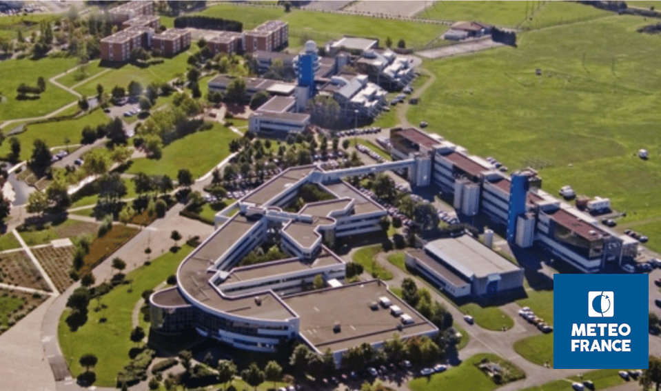
Météo-France is a public administrative institution, the official meteorological and climatological service in France. As such, it exercises the State’s responsibilities in terms of meteorological safety. The institution is also in charge of managing and modernizing an observation network of the atmosphere, the surface ocean and the snow cover in France and overseas.
The institution is also present on an international level as it contributes to the programs and activities of the World Meteorological Organization (WMO) which sets standards that meet the shared needs of its Member States.
Météo-France’s research department, the Centre national de recherches météorologiques (CNRM), is a joint research unit with the CNRS. Météo-France is also a joint supervisor of the Laboratoire de l’Atmosphère et des CYclones (LaCy), the Service des Avions Français Instrumentés pour la Recherche et l’Environnement (SAFIRE), and the Observatoire Midi-Pyrénées (OMP).
Météo-France core missions are linked to the needs related to the protection of people and property: weather forecasting, knowledge of the climate and its evolution, physics and dynamics of the atmosphere and interactions between men, the climate and the atmosphere…
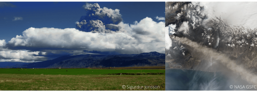
The knowledge of weather conditions is of huge importance for the aviation industry for example. Landing, taking off and even flying safely depends on weather conditions. The perfect example of this huge importance is the eruption of the volcano Eyjafjallajökull which occurred in April 2010. The Icelandic volcano released a thick ash of smoke which disrupted European air traffic, causing five days of complete interruption of traffic: the largest closure of airspace decreed in Europe, not without financial consequences as it led to considerable losses.
Indeed, volcanic ash which tends to settle in the atmosphere is dangerous as it can be sucked into the plane’s engines, then, melt, and finally clog the jet engines. It can cause air plane accidents.
Hence the importance of using state-of-the-art remote sensing measuring instruments to determine for instance the localization, the characterization and the concentration of aerosols in the atmosphere. For this purpose, Météo-France works in collaboration with the LOA (Laboratoire d’Optique Atmosphérique) to manage and maintain a network of efficient solutions and link several instruments such as LiDARs and CIMEL photometers (ready-to-use by AERONET) for more accurate data and considerably reduced uncertainties.
To this end, CIMEL works in close collaboration with Météo-France and ensures to provide quality and constantly improved instruments to meet the urgent needs in terms of security.
Actually, CIMEL also provides instrument synergies between Photometers and LiDARs through a unique monitoring software iAAMS, dedicated to the aerosols study and analysis. The obtained parameters are the characterization of aerosol types, the extinction and backscatter profile of mass concentration. Cimel’s AAMS is able to automatically locate, identify and quantify aerosols, layer by layer, day and night.
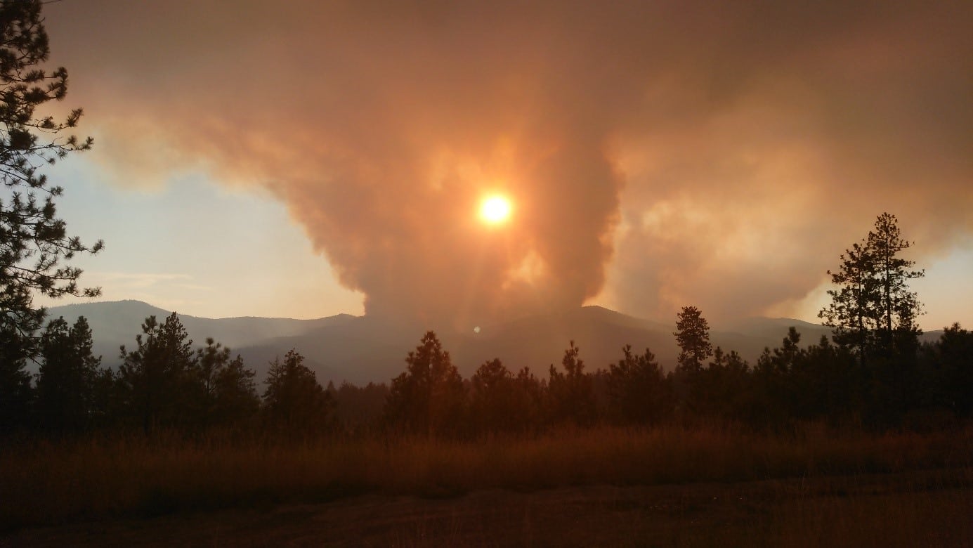
US west coast forests are more and more in the grip of Wildfires.
Keywords : Aerosols, LiDARs, MicroLiDARs, Monitoring, Earth observation, Remote sensing, Wildfire, Smoke, Ash, Fires, Climate Change, Global Warming, Atmospheric Monitoring, Mobile Solutions, Air Quality
June 28th 2022
According to a recent UN report, forest fires will continue to increase by the end of the century. It is especially the case on the west coast of the United States, which is one of the countries most affected by this phenomenon. Whether they are natural or human-caused, these fires are devastating on a large scale.
The global warming makes the conditions more favorable to the start of fires and their proliferation. The climate change is worsening the impacts by prolonging the fire seasons.
California is the most wildfire-prone state in the United States. In 2021, over 9000 wildfires burned in the Southwestern state ravishing nearly 2.23 million acres.
Fires are a danger to life on the planet: smoke inhalation, soil degradation and water pollution, destruction of the habitats of many species… Not to mention the aggravation of global warming due to the destruction of forests, crucial to absorb the carbon that we emit.
Therefore, on summer 2019, NASA initiated FIREX-AQ mission so as to investigate on fire and smoke from wildfire using several measurement instruments across the world, and especially in the US.
NASA uses satellites combined with airborne and ground-based instruments to decipher the impact of wildfires.
The emissions of ash clouds resulting from the fire can be transported thousands of miles and can have an impact on air quality for example as they are responsible for a large fraction of the US PM2.5 emissions. Due to its microscopic size, PM2.5 is easily inhaled and has the potential to travel deep into our respiratory tracts, it can also remain airborne for long periods.
To date, wildfire outputs are still poorly represented in emission inventories.
The overarching objectives of FIREX-AQ are to:
Provide measurements of trace gas and aerosol emissions for wildfires and prescribed fires in great detail
Relate them to fuel and fire conditions at the point of emission
Characterize the conditions relating to plume rise
Follow plumes downwind to understand chemical transformation and air quality impacts
Assess the efficacy of satellite detections for estimating the emissions from sampled fires
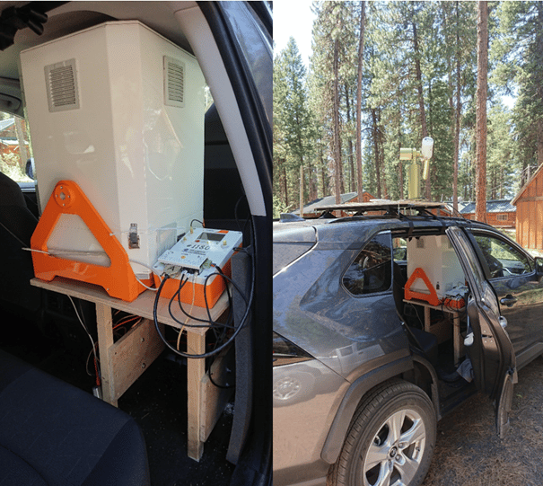
For this purpose, CIMEL provided CE376 micro-LiDARs as well as its network of CE318-T photometers through AERONET. These solutions allowed detailed measurements of aerosols emitted from wildfires and agricultural fires to address science topics and evaluate impacts on local and regional air quality, and how satellite data can be used to estimate emissions more accurately.
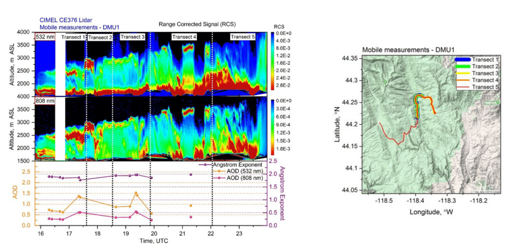
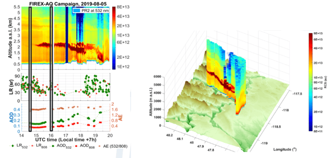
Indeed, the synergy of the photometer with the mobile CE376 LiDAR allows profiling the extinction at 2 wavelengths (532, 808 nm) and of the Angstrom Exponent (AE). AE vertical profile and the depolarization capabilities of the CE376 allow identifying the aerosol type (fine/coarse). Below are some results from the FIREX-AQ 2019 mission:
Figure 2: Mapping of smoke vertical and spatial dispersion thanks to mobile LIDAR and photometer measurements by Dr. Ioana POPOVICI.
Figure 3: Mapping and modelization from FIREX-AQ campaign in Western US (2019) by LiDAR CE376.
FIREX-AQ experience proved that we are able to embark compact remote sensing instruments and install them quickly on site to access harsh environments and get close to fire sources, which has not been done before. Actually, it is the first time a LIDAR reaches that close to fire sources in a mountainous region.
Giles, D. M. and Holben, B. and Eck, T. F. and Slutsker, I. and LaRosa, A. D. and Sorokin, M. G. and Smirnov, A. and Sinyuk, A. and Schafer, J. and Kraft, J. and Scully, A. and Goloub, P. and Podvin, T. and Blarel, L. and Proniewski, L. and Popovici, I. and Dubois, G. and Lapionak, A., (2020), Ground-based Remote Sensing of the Williams Flats Fire Using Mobile AERONET DRAGON Measurements and Retrievals during FIREX-AQ, 2020, AGU Fall Meeting Abstracts.
The Canadian Arctic is probably one of the best areas to conduct climatological studies, especially on global warming given the purity of the atmosphere in this zone, especially due to the absence of anthropological pollution.
Nevertheless, this rather hostile land, due to its temperatures, can make the difficulties of recording measurements very real. Consequently, there is a lack of measurements in the Arctic, hence the need to install platforms with robust and reliable measuring instruments.
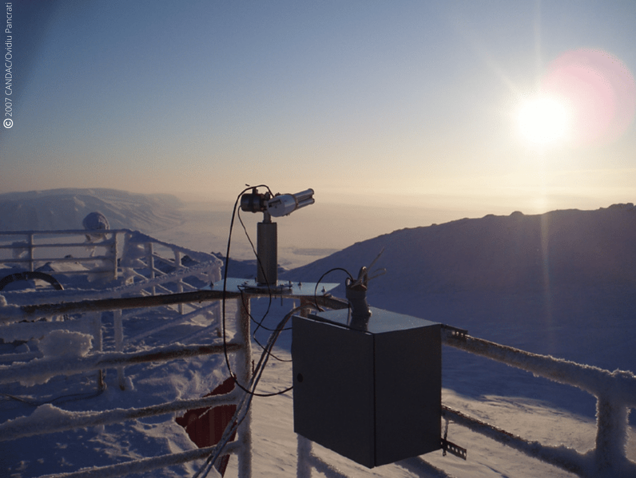
Some of those platforms, especially PEARL and OPAL, have a particular emphasis on the Arctic because Canada has a significant portion of its territory in the Arctic.
The Polar Environmental Atmospheric Research Lab (PEARL) and the zerO altitude Polar Atmosphere Laboratory (OPAL) which is part of PEARL, is operated by the CAnadian Network for the Detection of Atmospheric Change (CANDAC) which is a member of AEROCAN. Formed in 2005, PEARL constitutes a network of universities and government researchers dedicated to studying the changing atmosphere over Canada.
The first task of PEARL was to renew and operate the existing laboratory at Eureka in Nunavut, which was created to contribute to the world-wide effort to intensively study the Arctic region through AEROCAN.
The AEROCAN photometer network is run as a joint collaboration between the Université de Sherbrooke and the Meteorological Service of Canada (MSC). It is a full-fledged sub-network of the much larger AERONET network of Cimel photometers and benefits from all the services that AERONET offers.
Objectives:
Understanding atmospheric change over Canada
Integration of measurements taken from space, aircraft, balloons and the ground
Provision of quality-controlled research datasets to researchers
Linkage with international networks for data exchange and supranational planning
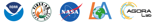
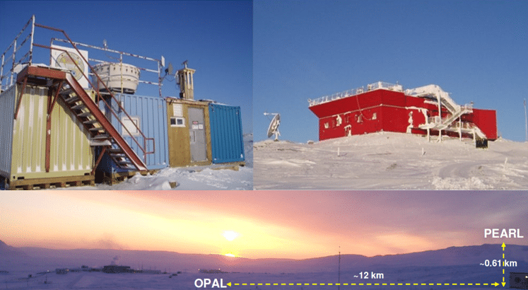
In addition, PEARL undertakes measurements that are simultaneous with those made by various satellite instruments. These “validation” measurements are extremely effective because of the location of PEARL and OPAL, and they further enhance the science return of the research as they use state-of-the-art technology solutions like theCE318-T Photometer.
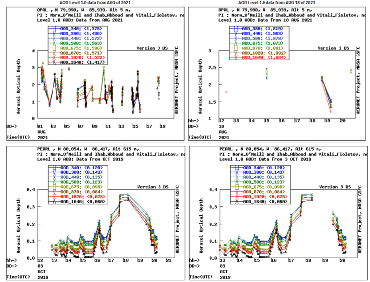
PEARL is located at Eureka, Nunavut (80N, 86W) on Ellesmere Island in Canada’s high Arctic, 450 km north of Grise Fiord, the most northerly permanent settlement. This photometer site is 1,100 km from the North Pole. OPAL is located about 12 km southeast of the PEARL ridge lab which is at an elevation of 610 m. This dual placement was designed to study the layer between the two sites as well as provide an element of redundancy for the AOD measurements.
Figure 1: Location of PEARL and OPAL photometer sites (upper pictures : 2007 CANDAC/Ovidiu Pancrati, bottom picture: Norm O-Neill, Université de Sherbrooke)
Figure 2: PEARL CE318 Photometer pointing to the sun for a measurement scenario
Figure 3: Latest measurements from Opal (above) and Pearl (bottom) photometers depicting AOD (Aerosol Optical Depth). Credits: NASA AERONET: https://aeronet.gsfc.nasa.gov/
Results:
A multi-year AOD and effective radius climatology for the high Arctic showed a number of consistent features using the Cimel CE318-T Photometer: • Spring to summer decrease of fine-mode AOD (probably attributable to biomass burning and/or anthropogenic pollution) • Significant correlation of fine mode AOD with CO (Carbon monoxide) concentration which indicates a predominance of biomass burning aerosols throughout the entire year • West to East decrease in AOD on a pan-Arctic scale Another study (Antuña-Marrero et al., 2022) has been conducted for water vapor research. It shows that it is feasible to use Cimel CE318-T Photometer AERONET observations in the Arctic for water vapor research, considering the robust quantification of its dry bias that has been established. As a matter of fact, AERONET imposes standardization of instruments, calibration, processing and distribution that Cimel is the exclusive provider. Its IWV (Integrated Water Vapor) observations are an ideal standard dataset to re-calibrate or homogenize the rest of the instrumental IWV observations to a predefined absolute standard dataset.
References:
Antuña-Marrero, Juan Carlos & Román, Roberto & Cachorro, Victoria & Mateos, David & Toledano, Carlos & Calle, Abel & Antuña Sánchez, Juan Carlos & Vaquero-Martínez, Javier & Antón, Manuel & Baraja, Ángel. (2022). Integrated water vapor over the Arctic: Comparison between radiosondes and sun photometer observations. Atmospheric Research. 270. 106059. 10.1016/j.atmosres.2022.106059.
AboEl‐Fetouh, Y., O’Neill, N. T., Ranjbar, K., Hesaraki, S., Abboud, I., & Sobolewski, P. S. (2020). Climatological‐scale analysis of intensive and semi‐intensive aerosol parameters derived from AERONET retrievals over the Arctic. Journal ofGeophysical Research: Atmospheres, 125, e2019JD031569. https://doi.org/10.1029/2019JD031569
Mölders, N. and Friberg, M. (2020) Using MAN and Coastal AERONET Measurements to Assess the Suitability of MODIS C6.1 Aerosol Optical Depth for Monitoring Changes from Increased Arctic Shipping. Open Journal of Air Pollution, 9, 77-104. https://doi.org/10.4236/ojap.2020.94006