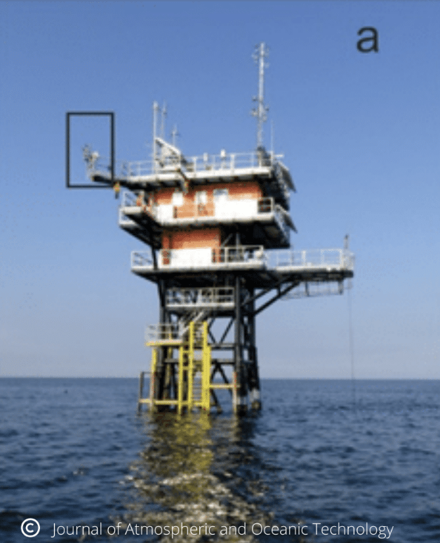
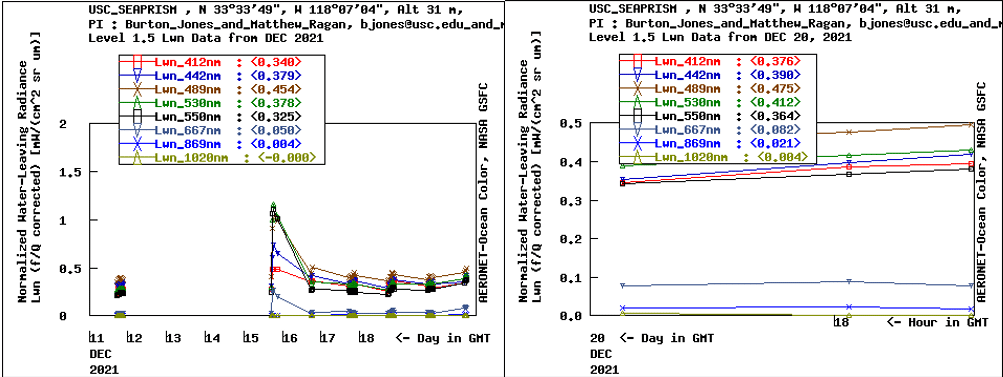
Eureka offshore oil platform provides continuous aerosols data recorded by CE318-TV12-OC (SeaPRISM) for NASA AERONET.
Keywords : Aerosols, photometer, water radiance, monitoring, ocean properties, ocean color, Earth observation, remote sensing, CAL/VAL, SeaPRISM.
February 9th 2022
Since 2002, more than 31 OC measurement sites have been integrated on the NASA AERONET OCEAN COLOR network through offshore fixed platforms and coastal platforms all around the world. Thanks to numerous collaborations between environmental sciences and energy industries such as discussed below, the number of Ocean Color measurement sites keeps growing.
In collaboration with University of Southern California (USC), the SeaPRISM site at the oil rig platform Eureka was installed in the Los Angeles Harbor and was initially operational in April 2011. CE318-TV12-OC (SeaPRISM) photometers are part of the AERONET network of automated instruments designed to make automated measurements of aerosols around the world.
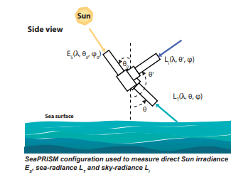
The SeaPRISM instrument has been modified to also view the ocean surface and measure ocean color remote sensing reflectance as well as the aerosol measurements. Data is currently flowing to NASA AERONET as well as NRL-SSC (The Naval Research Laboratory detachment at Stennis Space Center (SSC), Mississippi) and Oregon State University (OSU) for matchups. Data has been collected routinely since June 2012 to date.
Continuity of the ocean color products between ocean color satellites is required for climate studies, as well as to enhance the operational products used in ecological monitoring and forecasting, such as accurately monitoring ocean water quality and determining changes along our coastlines. In addition, inter-satellite product comparisons are essential for data continuity into the future.
The JPSS (Joint Polar Satellite System) calibration and validation team has developed an infrastructure to evaluate VIIRS (Visible Infrared Imaging Radiometer Suite) Ocean Environmental Data Records (EDRs): routinely nLw(λ) and chlorophyll are evaluated against existing satellites data measurements. Ocean color products are based on nLw( λ) from which specific products of chlorophyll, backscattering coefficients, absorption coefficients, and diffuse attenuation coefficients are computed.
Therefore the accurate radiometric retrieval of the nLw( λ) is considered essential for the production of any ocean color product. A web-based with the VIIRS data matching the satellite data from Platform Eureka SeaPRISM was created in order to provide reliable data. The CE-318 of the oil platform Eureka helps to validate the satellite data provided by VIIRS on the JPSS.
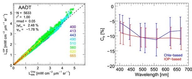
Here are some results performed recently by the CE318-TV12-OC (SeaPRISM) located at Platform Eureka depicting the Normalized Water-Leaving Radiance.

Bibliography:
Curtiss O. Davis, Nicholas Tufillaro, Jasmine Nahorniak, Burton Jones, and Robert Arnone “Evaluating VIIRS ocean color products for west coast and Hawaiian waters”, Proc. SPIE 8724, Ocean Sensing and Monitoring V, 87240J (3 June 2013); https://doi.org/10.1117/12.2016177
https://earthdata.nasa.gov/earth-observation-data/near-real-time/download-nrt-data/viirs-nrt